Drone photography is transforming real estate marketing, helping homes sell 68% faster and increasing sale prices by up to 10%. It’s a cost-effective tool, with sessions ranging from $150–$500, delivering an ROI that can exceed 1,000%. Here’s why it works:
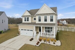
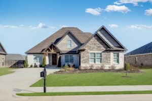
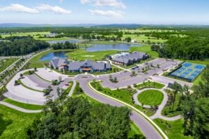
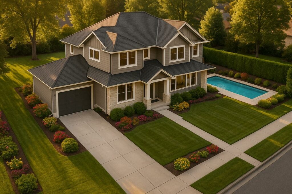
- Better Property Showcasing: Highlights large yards, lot boundaries, and nearby amenities.
- Financial Benefits: Listings with drone photos get 94% more views, attract more inquiries, and sell quicker.
- Practical Tips: Schedule shoots during golden hours, prep properties beforehand, and plan a detailed shot list.
Drone photography is not only about visuals; it directly impacts sales speed, property value, and client satisfaction. With 83% of sellers preferring agents who use drones, it’s a must-have for staying competitive. Whether hiring professionals or investing in equipment, drone photography offers a clear path to maximizing returns.
How to Price Real Estate Drone Photography Like a Pro
Money-Saving Methods for Drone Photography
There are smart ways to cut costs when using drone photography, especially for real estate professionals looking to get the most value without overspending.
Professional Services vs. Equipment Purchase
Real estate agents often face a choice: invest in drone equipment or hire professionals. Drones can range from $200 to $2,500, but owning one comes with added expenses like maintenance, licensing, insurance, training, and software. On the other hand, platforms like HomeJab offer aerial photography packages starting at $249, eliminating the need for upfront investments and regulatory concerns.
"Successful realtors focus on selling real estate and hire the experts." – Caroline York, with 16+ years in residential real estate
Once you’ve decided on a service or ownership model, the next step is to make each session as efficient as possible to keep costs low.
Optimizing Drone Photo Sessions
A little preparation can go a long way in maximizing the value of your drone photography sessions. Try these tips:
- Time it right: Schedule shoots during the "golden hours" (shortly after sunrise or before sunset) for the best lighting conditions.
- Prep the property: Clear clutter, reposition outdoor furniture, and ensure driveways are free of parked cars.
- Plan ahead: Create a detailed shot list highlighting key property features so photographers can work quickly and efficiently.
These steps not only save time but can also help you avoid unnecessary reshoots.
Affordable Drone Photo Options
If you’re looking to save even more, there are additional strategies to make drone photography more budget-friendly. Professional drone imaging services typically cost between $70 and $250 per hour. Here’s how to stretch your budget further:
- Group multiple properties in the same area for bulk discounts.
- Pick packages that combine aerial and ground-level photography.
- Opt for flat-rate services instead of hourly billing to avoid surprises.
- Work with photographers experienced in real estate to ensure quality and efficiency.
Using Drone Photos in Marketing
Drone photography can significantly enhance property visibility and engagement. Studies show that listings featuring aerial photos tend to sell more quickly, making it crucial to use these images strategically. Let’s explore how to maximize their impact in MLS listings and beyond.
Adding Aerial Photos to MLS Listings
Since 97% of homebuyers begin their property search online, incorporating aerial photos effectively in MLS listings is a game-changer. Here’s how to make the most of them:
- Start with an aerial establishing shot to showcase the property’s location and surroundings.
- Include 8–10 aerial photos per listing, meeting the expectations of 57% of buyers who prefer this range.
- Highlight unique features, such as spacious backyards, pools, or proximity to amenities.
- Ensure all photos meet MLS resolution and formatting requirements.
Strategic use of aerial imagery has been shown to increase showing requests, proving its value in real estate marketing.
Social Media Distribution Methods
Social media platforms offer another powerful avenue to share aerial imagery, expanding your reach and engagement.
"Aerial shots show everyday places in a new way. This surprise factor is key to grabbing attention online"
Here’s how to make the most of popular platforms:
Instagram & Facebook
- Use carousels to display multiple aerial perspectives.
- Leverage video tools to create dynamic property tours.
- Add location tags to boost local visibility.
- Incorporate relevant hashtags to extend your reach.
Video Platforms
- Create short-form videos tailored for TikTok and Instagram Reels.
- Produce cinematic property tours for YouTube.
- Pair your videos with trending music.
- Post during peak times to maximize audience engagement.
Mixing Drone Photos with Other Content
For a well-rounded property showcase, combine aerial footage with other types of content like virtual tours and floor plans. This blend enhances spatial understanding and creates a more immersive experience for viewers:
- Pair aerial footage with virtual tours to capture both the big picture and finer details.
- Overlay overhead views with floor plans or virtual staging for added clarity.
- Craft highlight reels that seamlessly mix ground-level and aerial shots.
"The best drone videos don’t just show a place – they make you feel like you’re there. That emotional connection is what turns viewers into customers"
This integrated approach resonates strongly with sellers, as 83% prefer working with agents who incorporate drone photography into their marketing strategies.
sbb-itb-82c5f45
Measuring Drone Photography Results
Evaluating the results of drone photography requires a clear focus on key performance indicators (KPIs). By analyzing data, professionals can fine-tune their strategies to achieve better outcomes and higher returns.
Performance Metrics to Track
If you want to measure the impact of drone photography effectively, here are the metrics you should keep an eye on:
Listing Performance
- Days on market (DOM): How quickly properties sell.
- Number of showings: The volume of in-person or virtual viewing requests.
- Website traffic: Engagement rates on property listings.
- Lead generation: The number of potential buyers expressing interest.
- Final sale price: Comparing the sale price to the original asking price.
Tracking these metrics often reveals faster sales and increased interest from potential buyers.
Marketing Engagement
- Social media metrics: Reach, likes, shares, and comments.
- Video view duration: How long viewers watch aerial footage.
- Virtual tour completion: The percentage of viewers who finish online tours.
- Email click-through rates: Engagement with marketing emails.
- Inquiry source tracking: Identifying where leads originate.
These data points help determine how drone visuals contribute to marketing success, offering a clearer picture of their overall value.
Results Analysis Methods
A structured approach to analyzing results can highlight areas for improvement and justify the investment in drone photography.
Comparative Analysis Framework
The table below illustrates the difference drone photography can make:
| Metric | With Drone Photos | Without Drone Photos |
|---|---|---|
| Average Days on Market | 68% faster sales | Baseline |
| Listing Views | 73% more views | Baseline |
| Buyer Inquiries | 403% more inquiries | Baseline |
| Lead Quality | Higher engagement rates | Baseline |
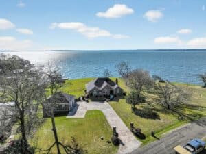
Real-World Success Example
A luxury California property used aerial footage to showcase its sprawling grounds and ocean views. The result? The home sold for 15% above the initial listing price.
Key Steps for Analysis
- Establish a baseline: Record metrics before introducing drone photography.
- Monitor campaigns: Track both numerical data and qualitative feedback during marketing efforts.
- Identify trends: Regularly review performance data to spot patterns.
- Calculate ROI: Compare the costs of drone photography with measurable benefits like higher sales prices or faster sales.
Cost-Benefit Highlights
- Shorter time on the market, reducing overall marketing expenses.
- Greater visibility for properties, leading to more interest.
- Higher-quality leads, meaning fewer wasted inquiries.
- Improved branding and reputation.
- Increased client satisfaction through enhanced presentations.
Legal and Safety Requirements
Using drones for real estate photography comes with a responsibility to follow strict regulations and safety practices. Ignoring these rules can lead to hefty fines or other legal consequences.
FAA Rules and Licenses
The Federal Aviation Administration (FAA) has clear guidelines for commercial drone use. To legally take aerial photos of properties, you’ll need:
- A Remote Pilot Certificate with a small UAS rating
- Drone registration, which costs $5 per drone and lasts three years
- Remote ID compliance for your drone
Getting certified requires passing the FAA’s Part 107 test, which costs $175 and must be taken at an approved center.
"Don’t buy a drone and just start flying. The FAA has strict rules and regulations about pilot certificates, prohibited airspace usage, drone operations at night and much more." – National Association of REALTORS®
Once you’ve met these legal requirements, it’s wise to protect your business further by securing proper insurance.
Insurance Requirements
Insurance is a smart safeguard for your drone operations. Here are some common coverage options to consider:
| Insurance Type | Coverage Amount | Average Annual Cost |
|---|---|---|
| Basic Liability | $1M | $750 |
| On-Demand Coverage | $1M | $10/hour |
| Equipment Protection | Varies | $230+ |
| Comprehensive Policy | $1M+ | $600–800 |
Although the FAA doesn’t require insurance, having it is critical for protecting your business. Many drone operators opt for both liability and equipment coverage, especially since commercial drone setups can easily cost more than $10,000.
Weather and Scheduling
Weather plays a major role in drone photography. Follow these best practices to ensure safe and efficient operations:
- Keep an eye on weather forecasts and local airspace restrictions.
- Conduct pre-flight equipment checks and maintain a clear visual line of sight during flights.
- Log every flight and have a backup plan ready in case of unexpected changes.
Conclusion: Implementing Drone Photography
Main Benefits Summary
Drone photography offers a powerful way to boost property sales and online engagement. Listings featuring drone imagery attract 94% more views compared to those with traditional photos. Agents using drones often see up to a 73% increase in listings and a 68% rise in deal closings.
"Homes displayed with aerial shots are 68% more likely to sell, and that offering prospective buyers a bird’s-eye view of the property not only enhances marketing efforts but also helps buyers establish a stronger emotional connection with the property." – Whitney Savoie, FlyGuys Nationwide Data Capture
It’s also worth noting that 83% of home sellers prefer agents who use drone photography. This makes aerial imagery a must-have for any real estate professional aiming to stand out in the market.
Getting Started with Drone Photos
If you’re ready to leverage drone photography, here’s how to make it a seamless part of your marketing plan:
| Strategy | Benefit | Cost |
|---|---|---|
| Hire Professional Services | Quick, high-quality results | $195–500 per property |
| Schedule During Golden Hours | Maximize visual impact | Included in base cost |
| Share Across Platforms | Boost listing views by 94% | No extra charge |
Scheduling shoots during golden hours – early morning or late afternoon – ensures properties are captured in the most flattering light. Professional drone services typically provide 18–24 aerial photos along with a 3–5 minute video, delivering a comprehensive visual package.
For a reliable option, consider using HomeJab (https://homejab.com), which offers on-demand drone photography with quick turnaround times.
"As technology continues to evolve, drones will likely become an integral part of the real estate marketing toolkit." – Whitney Savoie, FlyGuys Nationwide Data Capture
FAQs
Should real estate agents hire professional drone services or invest in their own equipment?
When weighing the choice between hiring professional drone services and purchasing your own equipment, it’s essential to think about your budget, specific needs, and how much time you can dedicate.
Hiring a professional service can be a smart option if you don’t need aerial photography on a regular basis. It saves you from making a hefty upfront investment – high-quality drones typically range from $1,000 to $3,000. Plus, you won’t have to worry about ongoing expenses like maintenance, insurance, or licensing. Professional operators also bring the expertise needed to comply with FAA regulations and deliver polished, market-ready images without delay.
On the flip side, owning a drone might be a better fit if you need frequent access to aerial shots or prefer having control over your schedule. That said, ownership comes with its own set of responsibilities. You’ll need to learn how to operate the drone, get the necessary certifications, and handle costs for training, maintenance, and repairs.
Ultimately, the decision boils down to how often you’ll rely on drone photography and whether managing your own equipment is worth the added effort compared to the ease of outsourcing.
What legal and safety rules should I follow when using drones for real estate photography?
To use drones for real estate photography legally and safely in the U.S., there are a few key rules you need to follow:
- FAA Certification: You’ll need a Remote Pilot Certificate under FAA Part 107, which requires passing an aeronautical knowledge test.
- Drone Registration: If your drone weighs more than 0.55 pounds, it must be registered with the FAA.
- Altitude and Airspace Rules: Keep your drone at or below 400 feet and stay out of restricted airspace unless you have the proper authorization.
- Privacy Considerations: Always get permission from property owners and follow local and federal privacy laws.
- Avoid Crowds: Never fly over people who aren’t part of your operation.
Following these guidelines ensures your drone photography stays within the law and helps you capture impressive aerial views for your real estate listings without running into trouble.
How can real estate professionals use drone photography on social media to boost property visibility?
Drone photography has become a game-changer for boosting property visibility on social media. Stunning aerial shots and dynamic videos can present homes from fresh, attention-grabbing perspectives, making them pop on platforms like Instagram, Facebook, and TikTok. In crowded social feeds, properties with drone imagery naturally stand out, catching the eyes of potential buyers.
You can take it a step further by using drone footage to craft short, immersive virtual tours. These bird’s-eye views not only showcase the property’s key features but also its surroundings, creating a narrative that sticks with viewers. Integrating high-quality drone content into your social media plan can draw more attention and take your marketing efforts to the next level.